
UDALLS COVE PRESERVATION COMMITTEE

UCPC's "CPR" Work for the Community:
CONSERVATION, PRESERVATION and RESTORATION
For over half a century, the mission of the Udalls Cove Preservation Committee has been the Conservation, Preservation and Restoration of the last remaining undeveloped wetlands and woodlands of the Udalls Cove watershed. We aim to conserve the few undeveloped areas we have left by helping plan their appropriate management; to preserve those areas to ensure they will be protected from development in perpetuity; and restore the areas that have been damaged by dumping, invasive species, erosion, etc.

UCPC’s efforts to secure preservation of these remaining undeveloped areas have been largely successful. On the Queens side of the county line, New York City in 1972 designated the corridor north of the LIRR as the Udalls Cove Park and Preserve. Six years later the City added park designation for the narrow, steep Ravine that lies to the south between the LIRR and Northern Boulevard. On the Nassau side of the county line, the Village of Great Neck Estates dropped its plans to build a golf course and also protected the large, healthy salt marsh as a park. (Visit our Map and Trails page to see the entire park.)
Acquisition of the privately held properties that made up the designated City park did not take place all at once, and has in fact not yet been completed. Time after time, UCPC has rallied community support and gotten crucial help from local elected officials to stave off threats of development for one parcel or another. Today, more than 95% of the area is publicly owned, but a few acres in the Ravine section of the park still remain to be acquired, and this continues to be UCPC's highest priority.
In 2017, using funding secured by our local elected officials at the urging of UCPC in partnership with other local organization, the New York City Parks Department acquired three one-quarter acre parcels on the east side of the Ravine. And in 2019 the Parks Department accepted donation of an additional quarter-acre parcel in the Ravine.
The parcels remaining to be acquired are outlined in red on the adjacent map. UCPC is working with the NYC Parks Department to acquire two additional quarter-acre-plus sized parcels on the west side of the Ravine. And we are working with our local elected officials to secure funding to purchase the largest remaining parcel, a one-quarter acre property near the southern end of the Ravine.
Acquiring these properties for the park furthers our "preservation" objective. To further our "conservation" and "restoration" mission, UCPC has carried out park improvement projects with a total value of well over $260,000! Read on for a few examples!

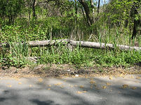
South Ravine Restoration Project
Starting in 2003 UCPC undertook a series of ambitious projects to restore a badly degraded area in the Ravine portion of Udalls Cove Park, near the Douglaston Firehouse. In Phase 1, we removed over a million pounds of concrete rubble that had been dumped there in the 1960s when the intention was to fill the entire Ravine for residential development. In Phase 2, we did extensive replanting of the area from which the concrete had been removed; much of that work was done by Eagle Scout Candidate Randy Seegert. In Phase 3, we completed an ambitous project to control severe erosion, remove invasives and replant with appropriate native species.
The erosion was caused by storm water running down from Church St. into a steeply sloped area of the park immediately adjacent to the Firehouse, carrying soil into Gabler's Creek below. We built a rock-lined drainage swale to control erosion; we replenished the lost soil with 200 cubic yards of new topsoil; and replanted the area with dozens of native trees and shrubs.
Finally, Eagle Scout Candidate Kevin Chen built a segment of trail through the newly restored area, and covered hundreds of linear feet of trail with fresh woodchips.
The total cost of these very successful projects was about $100,000.
Aurora Pond Restoration
Named to honor Aurora Gareiss, the legendary Queens conservationist and founder of the Udalls Cove Preservation Committee (UCPC), the pond was accidentally destroyed when it was dredged in the early 1990's. The dredging work at that time cut through a layer of clay-like soil which had allowed the pond water to collect. After it was dredged, the pond basin no longer held water, leaving it little more than a weed-choked mud puddle. Its restoration became a top priority for UCPC. The organization worked with the NYC Parks Department and with local elected officials to secure funding and develop a viable plan. After ten years of effort, work on the restoration project began in August, 2004.
Prior to the early 1990's, Aurora Pond was about an acre in size, and afforded an idyllically beautiful view for passersby on Sandhill Road. In the winter, local children skated and played ice hockey on the frozen surface. In the spring and summer, the Pond was home to hundreds of toads that would sing at night; and to a variety of water fowl and other wildlife.
The NYC Parks Department invited UCPC to work cooperatively on the design of the restoration project. In early 2000 UCPC submitted a detailed proposal laying out our recommended objectives and giving historical information about the size and location of the former Pond. UCPC also provided detailed comments on the draft design, and was gratified that the Department made adjustments to address our concerns.
Under the final restoration plan, a new basin for the Pond was constructed, and its bottom was lined with clay to replicate the original layer that kept the water in the Pond. The clay was covered with soil, and appropriate native vegetation was planted. Gabler's Creek, which flows through the Udalls Cove Ravine and past Aurora Pond, was re-routed into and through the restored Pond, assuring a year-round flow of fresh, oxygen-rich water. Water from natural springs near the foot of the Long Island Railroad embankment also flows into the Pond.
A viewing area adjacent to Sandhill Road, with a rustic Adirondacks-style railing, allows pedestrians to stop and enjoy the vista. A series of trails allow a relaxing stroll around the pond and through this area of the park. Native species of trees, shrubs and grasses were planted all around the Pond.
The Parks Department's attempt to dredge the Pond in the early 1990's was in response to siltation caused by decades of run-off from the steep slope to the west and the streets above. In order to prevent the same thing happening again, the gully down which storm water flows from Hillside Avenue into the pond was entirely reconstructed. The gully was lined with large rocks built into a series of attractive terraces that form little pools and waterfalls during a rain storm. By slowing down the water in these pools, much of the silt and sand settles out before reaching the Pond. In fact, much of the water seeps into the ground within the gully itself, helping to recharge the groundwater table.


As a last step in the restoration project, the 30+ year old fence that formerly separated the pond from Sandhill Road was removed. This fence, hand made by UCPC volunteers from old telephone poles, was rotting and unsightly and had collapsed in many places. It was replaced by a sturdy and attractive wooden railing.
The project, completed in 2006, cost over $1 million. However, the available funding allowed for the railing to be built only on one side of Sandhill Road, and only adjacent to the pond itself. UCPC invested an additional $50,000 from state and city grants and private contributions to continue the railing along a further distance on both sides of Sandhill Road.

Over the years since the completion of the pond restoration, major storms including Hurricanes Irene, Lee and Sandy have toppled large trees throughout the Aurora Pond section of the park, blocking trails and falling into the pond itself. UCPC has spent thousands of dollars to have these trees professionally removed, always with permits issued to us by the Parks Department. The logs from the fallen trees are used to line the trails, where they will slowly rot away and replenish the soil.


Restoring Wildlife
UCPC has installed two osprey nesting platforms, both of which have been occupied by nesting pairs since they were built.
The first was installed in 1997 on the west side of the Douglaston peninula; it is easily seen from the Douglaston LIRR station platform or from 233rd St. in the Doug-Bay community. The second was installed in 2004 near the Udalls Cove shoreline, and is easily seen from the Osprey Landing section of the park and from Douglas Manor's Memorial Field.
These magnificent birds -- relatives of eagles -- are native to virtually all of North America, and are widely distributed throughout the world. Their wingspans can reach five feet. They feed exclusively on fish, which they catch with sharp, curved talons. Circling over the water or sitting on a perch at the water's edge, they use their keen eyesight to spot fish swimming near the surface. After swooping down and seizing their prey, they return to their nest or perch to eat. While flying, they carry the fish face forward to reduce drag.
Ospreys build large nests of coarse sticks, seaweed and other material. Nests are commonly set high up in dead trees near the edge of lakes, rivers or the seacoast. In developed areas, however, most such nesting sites have been eliminated by human beings. Osprey platforms are an alternative to which these relatives of the eagles have readily adapted. Our platforms, build by UCPC volunteers, are five feet square. The one on the west side of Douglaston is mounted about 30 feet high on a utility pole supplied and installed for us by Con Edison; the one on the east side of Douglaston is mounted about 15 feet high on a structure built and installed by UCPC volunteers.
Ospreys are migratory, returning to our area in late March and heading south again in late September or early October.


SEE MORE WILDLIFE PHOTOS IN OUR PHOTO GALLERY

Photos above and below are by Steve Rossi


The Eagles Keep on Landing!
UCPC’s restoration and park improvement efforts have been aided immeasurably by the terrific efforts of Boy Scouts working to achieve their Eagle Scout badges – the highest rank a Scout can attain. We have been lucky to sponsor a whopping 33 Eagle Scout projects since 2006, as well as one Star and four Life Scout projects, and a Girl Scout Gold Award project. Here is the honor roll:
EAGLE SCOUT PROJECTS:
Troop 10:
• William Choi (split rail fence & cleanup at Virginia Point, 2009)
• Alex Yee (new trail at Virginia Point, 2009)
• David Guapisaca (footbridge and trail improvements at Virginia Point, 2013)
• Kevin Shea (Phase 1 of new North Ravine trail, 2013)
• Michael Feijoo (Phase 2 of new North Ravine trail, 2013)
• Andrew Tsao (split rail fence & trail improvements at Virginia Point, 2015)
• Max Lacoma (footbridge, trail improvements & tree planting at Virginia Point (2015)
• Ian Tsao (informational signs & tree planing at Great Neck entryway, 2017; also, successful petition
to remove concrete structure in Udalls Cove, endorsed by Belgrave Sewage Commissioners)
· Rain Gan (32' wooden walkways at Virginia Point, May 2023)
Troop 71:
• Bradley Shaffer (footbridge & trail improvements at Virginia Point, 2010)
• Brendan Watson (Phase 3 of new North Ravine trail, 2014)
• Jack Paganucci (wooden walkway and trail improvements at North Ravine, 2018)
• John Palmadessa (wooden steps and trail improvements at North Ravine, 2019)
- Daniel Cataldo (wooden steps & trail improvements Aurora Pond, planned for 2020)
· Brady Bosse (32 wooden walkways at Virginia Point, 2022)
· James Griffith (500+ foot trail extension in Old Oak Pond area. May 2024)
· Nick Tonorezos (600 foot trail in Great Neck Estates, November-December 2024)
· Chris Katsoulis (400 foot trail and wooden footbridge, Great Neck Estates, Spring 2025)
· Nic Katsoulis (400 foot trail, stairs, trail stabilization, Great Neck Estates, Spring 2025)
· Matt Milewski (built & installed 10 bat houses (project began elsewhere), May 2025)
· Max Tonorezos (425 feet of trail, split-rail fencing, Great Neck Estates, Fall 2025)
Troop 153:
• Alex Zeller (split rail fence, trail improvements and tree planting at Virginia Point, 2013)
• Mike Campese (new trail at Old Oak Pond, 2016)
• Clifford Lew (foot bridge at Old Oak Pond, 2016)
· Adnan Khan (new trail segment at Old Oak Pond, 2021)
· Jack Caldwell (32-foot wooden walkway, Virginia Point, Summer 2024)
Troop 183:
• Randy Seegert (tree planting & invasives removal in Ravine, 2006)
• Jesse Beckerman (split rail fence west of Aurora Pond, 2009)
• Kevin Chen (new South Ravine trail near Firehouse, 2013)
• Joseph DeRege (Phase 4 of new North Ravine trail, including footbridge over Gabler’s Creek, 2014)
• Amesh Sarecha (wooden walkway and trail improvements at Aurora Pond, 2017)
Troop 268:
• Lefteri Kapnisakis (Swallow nesting boxes at Virginia Pt. & Doug Bay, 2022)
· George Drakoulias (60-foot wooden walkway, Alley Pond Park, November 2025)
LIFE SCOUT PROJECTS:
• Kevin Chen, Troop 183 (tree planting at Virginia Point, 2012)
• Millen Rastogi, Troop 183 (removal of tires and other debris from Old Oak Pond, 2012)
• Jesse Beckerman, Troop 183 (tree planting and trail improvements at Aurora Pond, 2007)
· Mark Tsang, Troop 255 (recovered North Ravine Trail with fresh woodchips, October 2025)
STAR SCOUT PROJECTS:
· Mark Tsang, Troop 255 (trail maintenance in Alley Pond Park & Great Neck Estates, Summer 2025)
GIRL SCOUT GOLD AWARD PROJECTS:
· Samantha Palmadessa (invasive species removal & native tree planting, 2021)
SEE MORE PHOTOS OF THESE EAGLE SCOUT PROJECTS IN OUR PHOTO GALLERY
Reforestation
Starting in the 1990s, UCPC volunteers have worked to reforest the South Ravine portion of the park. The work focused on the six acre lot bordering Northern Boulevard, between the current TD Bank and 7-11 store, opposite the St. Anastasia Church. This area is the southern end of of the deep and steep-sided Udalls Cove Ravine, through which runs Gabler's Creek (see Geography). These six acres were completely filled in with concrete rubble during the 1960s and 1970s, and were first intended to be the site of a high school, and later a commercial strip mall. At UCPC's urging, and with the invaluable assistance of former State Senator Frank Padavan, funding was made available to purchase this property; and then the entire Ravine -- from Northern Boulevard to the Long Island Railroad -- was designated as an additional part of the Udalls Cove Park and Preserve (which had previously included only the area north of the LIRR).
The upper photo at right shows most of the six-acre lot as it appeared in the 1970s (photo by Pat St. John). The photo was taken from the parking lot of what was then the Carvel ice cream store. The Douglaston Firehouse is the large brick building on the right; Northern Boulevard is just out of view to the left. The lower photo was taken in 2019 from approximately the same location, in the parking lot of what is now the 7-11 store (photo by Walter Mugdan).


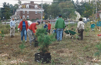
In the 1990s, UCPC volunteers began the task of reforesting what looked somewhat like a moonscape. There were formidable obstacles: the soil was very poor, with large amounts of concrete rubble at or near the surface. Nevertheless, with young trees provided by the NYC Parks Department and by the volunteers themselves, little by little the area was replanted.
The two photos at left were taken in 1995 by Pat St. John, and show some of the young volunteers at work. UCPC First Vice President Bruce Stuart, in the white tee shirt at left in the upper photo, oversaw the operation. UCPC Co-founder Ralph Kamhi, who was the organization's second President, is standing with hand on hip next to Bruce. Long-time UCPC Board member Jerry Vilbig is at the right. In the lower photo, UCPC member Tony Schiavo is in the red shirt and blue cap.
The lower photo shows a number of White Pine saplings that were being planted. In the photos that follow below, these little pines can be seen growing over the years into beautiful, mature trees.
To make that luxuriant growth possible, UCPC volunteers had to tend the young trees carefully. In the first months after planting they had to be watered when conditions were dry; and because of the poor soil conditions, for years thereafter they had to be provided with fertilzer. Wood chips were spread across the area to enrich the soil, and over time needles and leaves that fell each Autumn added valuable nutrients.


The photo on the left shows those same White Pine trees 10 years later, in 1995. The photo at right was taken in early 2019, nearly 24 years after the trees were planted. Those White Pines are now 30-40 feet tall, and provide a wonderful entryway into the South Ravine portion of the park. The South Ravine Trail passes under these evergreens.


And our reforestation work continues. In May, 2019 a beautiful, 14-foot tall Princeton American Elm tree was planted near the southern entry to the park, just east of the TD-Bank. The tree was planted in memory of David Lewis, a Douglaston native who worked as an arborist in our community, and later in Rock Springs, Wyoming. Dave passed away in 2018. His friends covered the cost of this fitting tribute, and UCPC’s landscape contractor did the heavy lifting, transporting and planting the tree.
The American Elm is native to eastern North America. In the 1930s Dutch Elm Disease arrived in the U.S., and within a few decades millions of American Elms died, nearly eradicating the species. In Princeton, NJ a cultivar had been raised since the 1920s because of its beauty; coincidentally, that cultivar has natural resistance to Dutch Elm Disease. The Princeton American Elm is a true native -- not a hybrid. This is the fourth Princeton American Elm we’ve planted in Udalls Cove Park, and all are thriving. The first was planted by Scout Troop 183 in 2007 on the north side of Aurora Pond (to the right of the entry from Sandhill Road); the second was planted in 2009 at Virginia Point when we carried out a major restoration project there; and the third in 2012, at another Virginia Point location, by Eagle Scout Kevin Chen of Troop 183.


Our South Ravine Restoration project, described above, included extensive reforestation with native species. The photo on the left shows the badly degraded condition of the site before the work began. The center photo shows the site with the invasives removed, and new soil being brought in to replace that which had been washed away by erosion. These two photos were taken in 2008. On the right is a view of the site in 2020 -- a lovely forest now thrives there, a short ten years after replanting.

The South Ravine forest in Spring, 2014. Photo by Walter Mugdan
Virginia Point Restoration


In 2009 the access to Virginia Point was completely overgrown with invasives shrubs (photo at left), making it impossible to get a view of the lovely marshland beyond. In November of that year UCPC undertook at $25,000 project to clear the site entirely (center photo), and replant with appropriate native species. The lovely results are shown in the picture at right, taken in 2014. The photo below shows the view from just beyond the replanted area.

Udalls Cove, viewed from Virginia Point; photo by Walter Mugdan
Great Neck Estates Trail Project
In Spring of 2024 UCPC proposed to the leadership of the Village of Great Neck Estates the establishment of a walking trail along the edge of the large Udalls Cove Marsh. The trail would stretch about a half mile from the south end of Mirrielees Circle all the way to the Udalls Cove shoreline. Along the way it would pass through two existing public park areas, Pond Park (adjacent to Laurel Drive) and the park at the foot of Juniper Drive. UCPC's proposal was that the work would be carried out by a series of Scouts completing Eagle Scout projects under UCPC's supervision. At least five sequential projects were anticipated. The Village Board of Trustees approved the project in Spring of 2024, and the first phase of the project was completed by Eagle Scout Nick Tonorezos of Troop 71 in December of that year. Three additional phases by Troop 71 Scouts followed in Spring of 2025 (Chris and Nic Katsoulis) and Fall of 2025 (Max Tonorezos). A fifth and final phase is planned for 2026.
